


Browsing by Subject "GIS"
Now showing items 1-20 of 32
-
The Double Binds of Indigeneity and Indigenous Resistance
(2016)During the twentieth century, indigenous peoples have often embraced the category of indigenous while also having to face the ambiguities and limitations of this concept. Indigeneity, whether represented by indigenous ... -
Figure 3.10 Top landowners in 1670.
(Esri Press, 2015) -
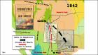
Figure 3.2 ArcScene, Irish Rebellion 1641 to 1642.
(Esri Press, 2015) -
Figure 3.6 Speculative ballybetagh boundaries of Ireland.
(Esri Press, 2015) -
Figure 3.8 Top landowners, 1641 (A) and 1670 (B).
(Esri Press, 2015) -
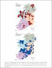
Figure 3.9 Top landowners in 1641
(Esri Press, 2015) -
GIS and machine peat extraction
(Statistical and Social Inquiry Society of Ireland, 1991)This paper outlines the use of a Geographic Information System (GIS), in the form of map overlays, to assist in the identification of socio-economic and physical environmental factors affecting extraction of peat by ... -
GIS Cartography Map Figures, 1, 2, 3, 4, 5, 6, 7 for Historical and Imagined GIS Borderlandscapes of the American West: Larry McMurtry?s Lonesome Dove Tetralogy and L.A. Noirscapes,
(Edinburgh University Press, 2020)Historical and Imagined GIS Borderlandscapes of the American West: Larry McMurtry’s Lonesome Dove Tetralogy and L.A. Noirscapes, Special Issue University Consortium of Geographic Information Science, International Journal ... -
Inventing the Grand Banks: A Deep Chart. Humanities GIS, Cartesian, and Literary Perceptions of the North-West Atlantic Fishery ca 1500-1800
(2020)As a feature of the Fish Revolution (1400–1700), the early modern “invention” of the Grand Banks in literary and cartographical documents facilitated a massive and unprecedented extraction of cod from the waters of the ... -
The Irish Juniper Monitoring Survey 2017
(National Parks and Wildlife Service. Department of Culture, Heritage and the GaeltachtIE, 2018-11) -
Local labour market information system: GIS in Belfast
(Statistical and Social Inquiry Society of Ireland, 1991)The evolving urban systems within the United Kingdom have attracted considerable attention, in particular, the changing geography of manufacturing industries at the region/urban level during a period of decline at ... -
Mapping the Viking Age World: A GIS Analysis of the Contemporary Evidence
(Trinity College Dublin. School of Histories & Humanities. Discipline of History, 2024)This thesis aimed to produce a critical reanalysis of Norse activity during the early Viking Age, c. 793-920, using Geographic Information Systems (GIS). By mapping and analyzing selected contemporary written and material ...