


Search
Now showing items 1-10 of 10
Figure 3.4 ArcScene topography of Cromwell's campaign in 1649?50.
(Esri Press, 2015)

Figure 3.3 Oliver Cromwell's seventeenth-century conquest of Ireland
(Esri Press, 2015)
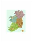
Figure 3.6 Speculative ballybetagh boundaries of Ireland.
(Esri Press, 2015)

Figure 3.8 Top landowners, 1641 (A) and 1670 (B).
(Esri Press, 2015)
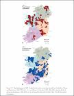
Figure 3.9 Top landowners in 1641
(Esri Press, 2015)

Figure 3.2 ArcScene, Irish Rebellion 1641 to 1642.
(Esri Press, 2015)
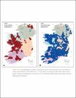
Figure 3.10 Top landowners in 1670.
(Esri Press, 2015)